Wonderland Trail
- Tina McLain
- Nov 16, 2020
- 12 min read

Updated: Jan 12, 2025
A 93 mile trail that circumnavigates Mt Rainier in Mount Rainier National Park.

Trail: Wonderland Trail
Distance: 93 miles
Elevation Range: 2450′ to 6726′
Ascent/Descent: +22500 ft / -22500 ft
Permits: Permit lottery system (online in March) for 70% of permits. The other 30% are walk up permits.
The Wonderland Trail circles Mt Rainer in Washington state. It can be done as a thruhike or section hike. There is a lottery system for permits and those are required to camp along the trail. One thing to note is with the permits behind a lottery system if you get a permit you just go with what you get which means odd days of long miles and short miles.
Explore by section:
Section 1 (2020) - Longmire to Mowich Lake

Total Distance: 34.6 miles Number of Days: 4 days Campsites: South Puyallup River, North Puyallup River, South Mowich River Dates: July 21 – 24, 2020
I originally planned on doing it as a thruhike, but I decided once I was on the trail to approach it in a way that works best for my body and not just trying to finish it just to say I did it. I ended up doing one section of trail from Longmire to Mowich Lake. So over the next few years my goal is to finish the Wonderland Trail.
Day 1 - Longmire to South Puyallup River

Daily Distance: 12.8 miles Elevation Range: 2823' to 5643' Ascent/Descent: +4496 ft / -3137 ft Sunrise/Sunset: 5:35 am / 8:51 pm Camp: South Puyallup River Camp Water: Get water before camp. No water near. Start time: 7:55 am (Longmire) End time: 6:50 pm (Camp) Points of interest: Indian Henry Patrol Cabin & Emerald Ridge Date: Tuesday, July 21, 2020
I was feeling excited and nervous before we started our trek. Right out of the gate we saw a mama deer with an adorable spotted baby right in the middle of the trail near Longmire.
I knew it was going to be a more challenging day with the mileage and ascent. I was definitely feeling it the first larger hill we went up out of Longmire. We agreed to have lunch near the Indian Henry Patrol Cabin. We all tried hiking together, but we all had our different paces. So after a while we all just spread out and hiked our own hike.
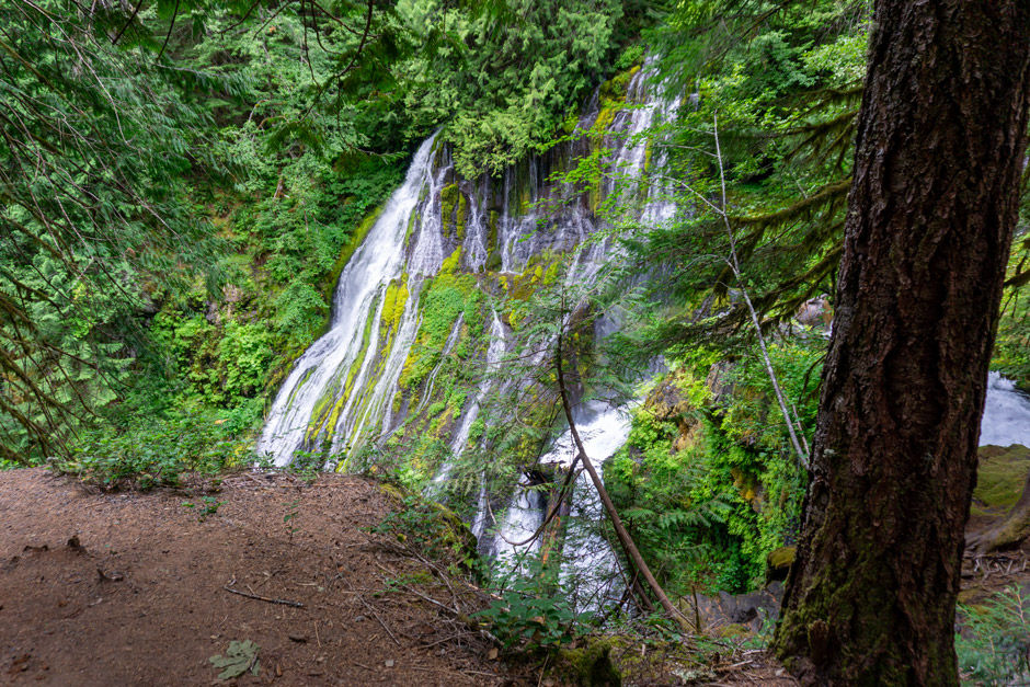
Near Devils Camp there was a really cool waterfall that can barely be seen from the trail as well as a really cool slot canyon.
As I neared a lake called Squaw Lake, I came across my first section of large snow patches. They lined the lake. My cousins had decided to stop there instead of at the next lake to eat. It felt so good to stop. I was totally soaked with sweat.
When we came upon the meadows near Indian Henry Patrol Cabin I was in awe. There was an incredible view of Mt Rainier with wildflowers everywhere. It was magical! After the cabin the trail worked its way downhill. At the bottom of the next valley there was a hanging bridge crossing the strong river a ways below which was followed by our next uphill section. I was really starting to feel rather weak and exhausted. I had to take my time climbing uphill to Emerald Ridge. I had to stop because I felt like I was going to pass out. I could tell I was really pushing my body, but somehow I made it to the top. It was such a cool view of the mountain. It was unreal. We took a break there and then hiked down to the bottom of the next valley where our camp was located. I’m not going to lie, a few tears were shed on my part.
I don’t know how I made it down to camp. My feet had gone past the point of hurting and were burning like hell. It wasn’t only a physically exhausting day, it was also a very emotionally draining day.

My journal notes at the end of the day:
- Lunch at meadow near Squaw Lake (12:15-12:50pm)
- Filled up water 2 different times
Beautiful points: - Indian Henry Patrol Cabin - Emerald Ridge
I honestly don’t know how I made it the last 4 hours of today. I pushed wayyy beyond what my body could handle. My feet were burning by the end of the day. I can’t believe I went almost 13 miles! It was so brutal. My body started to feel like it was going to flush so it felt like I needed to shit and throw up—not a fun exhaustion feeling. I saw a badger near Emerald Ridge. The views of the mountain were epic. Coming down from Emerald Ridge there was a large washout on the trail as it passed by a cliff. The trail was 1 ft wide and slanted. I didn’t feel good and was pretty scared. But I did it! I looked back and there was one precarious rock holding the whole trail up that looked like it was ready to go at any point. It was hundreds of feet down to the bottom of the canyon. Not a fan. Hopefully there’s nothing more like that. I’m so pooped and beyond exhausted. Tomorrow is a shorter day. Hopefully I’m not in too much pain. I feel like I’m not physically ready for this yet. I just have to make it to Mowich Lake and then I have the option to get off trail, which I probably will do. I want to cry, I feel so defeated and utterly exhausted.
Day 2 - South Puyallup River to North Puyallup River

Daily Distance: 6.7 miles
Elevation Range: 3654' to 5968'
Ascent/Descent: +2173 ft / -2661 ft
Sunrise/Sunset: 5:36 am / 8:50 pm
Camp: North Puyallup River Camp
Water: Water source approx. 1 mile before camp.
Start time: 10 am (S Puyallup)
End time: 4:50 pm (Camp)
Points of interest: St Andrews Lake and Aurora Lake
Date: Wednesday, July 22, 2020
To be totally honest, all the days after the first day kind of blur together. The only things that seem to help me remember are pictures and my journal notes from each day.
Today was a lighter mileage day, but definitely not a walk in the park. My body seems to be adjusting to the hiking well. I am able to go longer without breaks and I’m starting to find my own rhythm.
We took our time packing up in the morning and started hiking up a hill straight off. I saw traces of bear, there were a few places with bear scat along the trail. It was overcast on and off all day.
I really enjoyed hiking across the snowfields we came across. It also made trying to follow the trail fun, between looking for footprints and following the map we were able to stay on trail without a problem.
Saint Andrews Lake was so cool! We weren’t so sure if we reached the lake until we looked at the map because it was totally covered in snow. There was one little area that was snow free on the hill above the lake, so we sat on the ground and ate our lunch there. The fog rolled in while we were eating. There were little puddles of glacier blue water on top of the snow covering the lake. It was so cool! We filtered some water from the lake before we continued hiking. It was the most cold, crisp and delicious water I drank on the hike.
One of the most exciting sections was after Aurora Lake. The trail started descending quickly and went into steep, sharp switchbacks. The entire hillside was covered in quite a few feet of snow so there was no visible trail and it was at a steep slope. We had to climb and swing ourselves around smaller trees that and been downed across the trail. It was quite the precarious chore trying to navigate the trees with a 25 lb backpack on a steep slope. Thank goodness for micro spikes. It at least made it so we had some grip on the slope. None of us fell or got hurt. There were 2 guys behind us that we came across later on the trail when we were filling up with water. One of them had fell and bust his elbow and scraped up one of his knees. They hadn’t had micro spikes. They were hiking from Longmire to Mowich Lake in one day! Micro spikes really made our day easier.

My journal notes at the end of the day:
- Lunch at Saint Andrews Lake (12:55pm-1:40pm)
- Woke up at 6:30am and couldn’t get back to sleep
Today was actually a pretty awesome day. We started out hiking uphill for a long ways. I hiked alone basically the whole time. I found my groove and enjoyed it. I ended hiking through some big snow areas. The views of the area were beautiful. I met up with Luke and Lauren at St Andrews Lake and we ate lunch. There was one area with no snow, so that’s where we sat. Clouds and fog came blowing in, surrounding us and the frozen lake. Before it blew in we could see the top of Mt Rainier. The rest of the trail after the lake was almost all downhill and required the micro spikes on and off. My feet burned continuously from that point onward. Aurora Lake was tranquil and beautiful! Leaving the lake we encountered switchbacks covered in many feet of snow at a steep slant. Plus there were downed trees across our path due to there probably having been an avalanche in the past. It was quite the adventure. We used our micro spikes heavily! It was a beautiful rest of the hike down to camp. We filled up with water a ways before camp and met 2 guys hiking from Longmire to Mowich Lake in 1 day (34.6 miles!!!!). Ramen is freaking incredible. Tomorrow is another higher mileage day. I’m a bit nervous and I hope my feet don’t hurt as bad. I’m probably going to get off trail at Mowich Lake in 2 days. Tomorrow will tell.
Day 3 - North Puyallup River to South Mowich River Camp

Daily Distance: 10.8 miles Elevation Range: 2749' to 5260' Ascent/Descent: +1966 ft / -2912 ft Sunrise/Sunset: 5:37 am / 8:49 pm Camp: South Mowich River Camp Water: Get water before camp. Start time: 7:30 am (N Puyallup) End time: 3:20 pm (Camp) Points of interest: Golden Lakes Date: Thursday, July 23, 2020
One of the best mountain views of the day was going through a 1930s era fire burn zone with beautiful views of Mt Rainier. (It was 3.6 miles past North Puyallup Camp on our way to Golden Lakes). Golden Lakes Cabin is where we stopped and ate our lunch. There was a nice rock area we sat on that overlooked the lake behind the cabin. Hiking through the forest after passing Golden Lakes was beautiful. We were all starting to feel a bit worn towards the end of the day. It was a heavy descent down to South Mowich River and all of us were feeling our feet. South Mowich River was a powerful, rushing river and didn’t have an official bridge crossing. We followed the cairns and colored tape which lead us to a large log we walked across. There were a few smaller veins of the river that were very easy to jump rocks across. On the other side of the river and rock area was our campsite. We overestimated how long it would take us to get to camp so we ended up arriving earlier than we planned. It was actually really nice. We relaxed, ate a delicious meal and just enjoyed being.
I officially decided I was going to get off trail. My body was holding up pretty good, but I had other hikes I wanted to be able to do later in the summer and didn’t want to jeopardize those by pushing myself too far. With my chronic illness I have to walk a careful line with physical exertion. I really have to listen to my body.
We went to bed earlier since we were going to be getting up very early to start hiking the next morning.

My journal notes at the end of the day: - Lunch at Golden Lakes Patrol Cabin (10:46am-11:52am)
I forced myself to wake up twice from nightmares during the night. I got up to pee at 2:30am. I got to see the stars. I didn’t feel like I truly slept until early morning. I was out hard when I was woken up at 6:30am by my cousins. We started hiking at 7:30am. I was able to go longer today without having to stop as often. The first few miles of the trail were a steady uphill climb. Around 9:50am we made it to the top of the ascent. It was a pretty view. We stopped for a snack and sunscreen break. It was a beautiful hiking day. We made it to Golden Lakes Patrol Cabin by 10:46am where we planned to have lunch. It was very pleasant and everyone was relaxed. We hiked the rest of the way to camp and as we started going downhill we went into the fog/clouds. We stopped for a good 15 minute break. We laughed a lot. We filled up with some water a ways before camp. We then crossed South Mowich River which had many sections. We made it to camp by 3:20pm. We chose our campsite—we were the only ones there. We set up camp, relaxed and ate. I had a yummy supper and we had hot drinks. We’re going to bed early and waking up at 3am. It will be quite the adventure tomorrow! It’s 7pm now and I’m going to bed. Hopefully I’ll fall asleep quickly. I have decided I’m getting off trail tomorrow.
Day 4 - South Mowich River Camp to Mowich Lake

Daily Distance: 4.3 miles Elevation Range: 2608' to 4957' Ascent/Descent: +2460 ft / -171 ft Sunrise/Sunset: 5:38 am / 8:47 pm Camp: No camp - Got off trail at Mowich Lake Start time: 3:55 am (S Mowich) End time: 6:58 am (Mowich Lake) Points of interest: Crater Creek Waterfall and Mowich Lake Date: Friday, July 24, 2020
We woke up at 3am and packed up our gear as quickly as possible. We started hiking right before 4am. It was still pitch black out so we were hiking with our headlamps. Hiking in the dark is a totally different experience. We estimated we’d need 5 hours to hike the 4ish miles to Mowich Lake in time to meet my aunt and uncle who were bringing food restock and switching out people on and off trail. It was all uphill to Mowich Lake, plus hiking in the dark. We all hiked together the entire way instead of everyone hiking at their own pace. It was so cool to watch the light slowly filter through the forest. It was foggy and as it got lighter out it was sometimes hard to see with the headlamp in the fog. We made it to Mowich Lake way faster than we anticipated—a whole hour and a half earlier. We overestimated how long it would take us most of the time, which I guess is better than underestimating. It was really cold and there was snow on the ground around the lake. We sat right next to the water and watched the sun continue to rise, eventually breaking through the fog. The lake felt so magical with the snow around it and the fog covering it. It was such a wonderful end to my part on the Wonderland Trail.

My journal notes at the end of the day: - Note: 4.3 miles uphill to Mowich Lake (probably need 5 hours)
I woke up at 3am and we all quickly packed up our gear. We started hiking at 3:55am. It was pitch black and we were using our head lamps. There was a lot of uphill and then a small section of flat at the start. We ended up making pretty good time. I ended up leading since I’m the slow one. My legs, in the calves, were tight and cramping, but I didn’t stop very often. It was so cool getting to see the sky slowly lighten up. There was a lot of fog which made it pretty cool. As we neared the top we passed over a creek with a cascading waterfall. It was beautiful! There were a few steep parts of the trail before we got to the top. I saw a mama deer with a baby. We made it to the top at 6:58am. An hour and a half earlier than we planned. The car wouldn’t be at Mowich Lake until 8:30am. It was foggy and cold. We sat by the lake and ate for like 15-20 minutes. We were freezing so we went up to the parking area and sat on a picnic table and put a sleeping bag below and another over the top and huddled together until our ride/resupply got there.
Gallery
Food Cache Locations
Longmire
Mowich Lake
Sunrise
White River
Food caches can be mailed or delivered by hand to the food cache locations you choose before your trip. Since I didn’t stay on trail past Mowich Lake I didn’t have to restock on food. We decided not to use the food caches since at each food cache point (Mowich and White River) my aunt was going to meet us and deliver it to us so that I had the option to get off trail whenever I wanted. One thing to note if you use fuel for meals it cannot be mailed and has to be hand delivered. For more information directly from the source got to Mt Rainier National Park website for details on how to mail and deliver food caches.
Map
My Wild Adventure is not responsible for your safety, any possible injury, or anything that happens if you choose to follow anything on this website. Maps are not intended to be used for navigational purposes, but to give an overview of the route taken. By going outdoors you are solely responsible to know your strengths and limitations, be aware of current conditions and proceed with the appropriate caution. My Wild Adventure is not responsible for your choices and the outcome. Reference my disclaimer for more information on being responsible outdoors.