Murhut Falls
- Tina McLain
- Jun 9, 2025
- 3 min read

A hike to a waterfall in Olympic National Forest.

Waterfall Name: Murhut Falls
Waterfall Coordinates: 47.67374, -123.05005
Waterfall Elevation: 1180'
Access: Trail
Distance: 2.16 miles (round trip)
Elevation Range: 776' to 1066'
Ascent/Descent: +439 ft/-415 ft
Trail Type: In and out
Trail: Murhut Falls Trail #828
Outing Type: Day hike
Permits/Fees: None
Location: Near the Duckabush River area in Olympic National Forest, Washington, U.S.A.
Administration: Olympic National Forest
Ranger District: Hood Canal Ranger District
Date Accessed: March 2, 2025

This was a completely spontaneous hike and find. I saw it on the map after we finished the Rocky Brook Falls hike and decided we should see if we could access the trailhead and access this waterfall. We took Duckabush Rd to FS 2530. The roads were in pretty good condition (in my opinion.) When we got to the trailhead there were 3 cars already there, but there was room for us to park.

The trailhead was easy to spot. It started out immediately uphill and ascended for a while, then it somewhat evened out for a short bit. We came across only one downed tree across the trail. It was near the start and easy to get around. We ran into some people occasionally, but it never felt crowded.

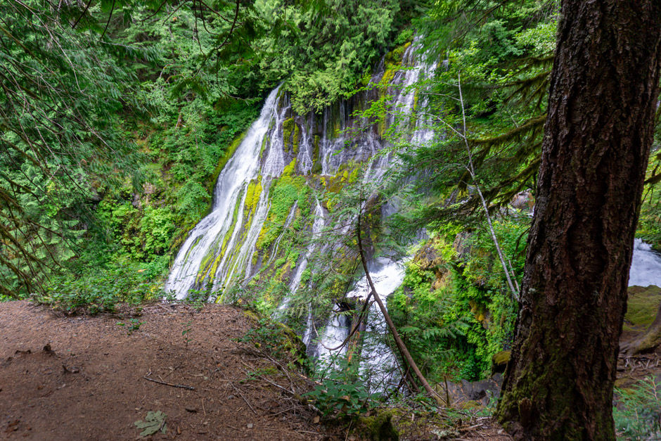
The trail eventually descended down towards the falls and the slope next to the trail got steeper. As we neared the falls the trail became more narrows with a steep drop along one side. There was lots of reinforcement to the trail due to erosion and slide problems it appeared. There was a bench a the end of the trail with an incredible view of Murhut Falls.

According to Waterfalls Northwest, Murhut Falls has two drops with the tallest drop being 117 feet tall. It's considered a tiered horsetail.

There appeared to be a bit of a "cave" behind the falls. There was no one else there while we were there. It is important to note that there is no way to get "close" to the falls, the end of the trail ends with a view of the falls from a good distance away.

We ended up taking a spur trail that lead down to the edge of the creek. It was pretty and we were able to see a few of the small drop falls, but there wasn't a clear view of Murhut falls from there. We could hear other waterfalls along the creek, but the next big one downstream wasn't visible from the trail and there was no point where it could be viewed from due to the steepness of the hillside.
The hike back was pleasant and we felt really lucky we had the waterfall all to ourselves.
Coordinates
Parking: 47.67667, -123.03853
Trailhead: 47.67660, -123.03862
End of trail: 47.67427, -123.05010
Spot along stream: 47.67442, -123.05052
Murhut Falls: 47.67374, -123.05005
How to get there
Take Duckabush Road from Duckabush for 3.7 miles. The road then turns into FS 2510 (Duckabush Collins Campground Road), continue for another 2.6 miles. Turn right on to FS 2530 (Murhut Road) and proceed for 1.25 miles. The trailhead is on the right (south) and the parking area is on the left (north).
NOTE: Duckabush Road is the best access to FS 2530 (Murhut Rd). Taking Fulton Creek Rd to Duckabush Collins C.G. Rd requires a high clearance vehicle. It's slow moving and narrow with some washouts. We took the route via Fulton Creek Rd on our way back to Highway 101 and it made for quite the adventure. I wouldn't recommend taking this route unless you're wanting to 4-wheel.
There was room for around 4-6 cars in the wide shoulder parking area.

Map
My Wild Adventure is not responsible for your safety, any possible injury, or anything that happens if you choose to follow anything on this website. Maps are not intended to be used for navigational purposes, but to give an overview of the route taken. By going outdoors you are solely responsible to know your strengths and limitations, be aware of current conditions and proceed with the appropriate caution. My Wild Adventure is not responsible for your choices and the outcome. Reference my disclaimer for more information on being responsible outdoors.