Swift Creek, Loowit & June Lake Loop
- Tina McLain
- Sep 9, 2024
- 7 min read

A hike along multiple trails to create a loop with mountain views, boulder fields, waterfalls, and a lake near Mt St Helens NVM.

Points of Interest: Chocolate Falls (was dry), Loowit Trail, June Lake, June Falls
Access: Trails, road walk
Distance: 5.45 miles (round trip)
Elevation Range: 2635' to 3727'
Ascent/Descent: +999 ft/-1037 ft
Route Type: Loop
Trail Route: Rock Pit Trail #244A, Swift Creek Ski Trail #244, Loowit Trail #216, June Lake Trail #216B, FS 250, FS 8300
Outing Type: Day hike
Winter Activity Options: Snowshoeing
Permits/Fees: NW Forest Pass required in certain parking areas.
Note: There is a section of the Loowit Trail that crosses a boulder field, there is no clear trail most of the time and requires following poles throughout the rocks and making your own way cross-country. There was one gully the trail went through that was steep but didn't require rope.
Parking Note: Could also start from Marble Mountain Sno-Park. The overflow lot is open for parking during the summer. Could also start at June Lake TH, but parking is more packed there.
Location: South side of Mt St Helens in Gifford Pinchot National Forest, Washington, U.S.A.
Administration: Gifford Pinchot National Forest
Ranger District: Mt St Helens National Volcanic Monument/Ranger District
Date Accessed: July 13, 2024

I've wanted to explore more of Mt St Helens and it has been years since I'd last been. My parents were up for going on a hike one Saturday so I pieced together a day hike that would have all the pieces I wanted to experience. It was a little over a two-hour drive up to where we were planning to start our hike. I'd had a rough week and I wasn't sure if I'd be up for the hike, so I had some alternate plans as backup.

We ended up missing the turn for Marble Mountain Sno-Park and drove a little farther up the road to right before the washout. There was a wide pull-off area with some other cars parked and I decided we should start there instead. We could have made it through the washout in our truck, but I didn't want to start from the June Lake Trailhead with the loop I was wanting to do. I decided to try hiking and if I needed to turn around I could.

We started our hike around 10:40am and it was already warm out. My mom forgot her hiking boots, but luckily I had brought my Bedrock Sandals which I've hiked in before. She decided she could use them.

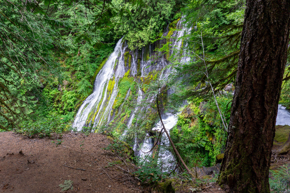
Waterfall Name: Chocolate Falls
Waterfall Coordinates: 46.15797, -122.17426
Waterfall Elevation: 3700'
Note: Seasonal water, was dry on July 13 when we were there.
We walked across the road from where we parked to the start of the Rock Pit Trail #244A which was more like a gravel road at the start. It went by a rock quarry where we saw three other hikers. The trail continued into the woods until it turned into Swift Creek Ski Trail #244. It was a nice grade going up. The trail got a bit narrower and had obviously been eroded due to winter melt off. There were no water sources along this trail.

At the intersection with Silver Trail #244C we stayed right on the Swift Creek Ski Trail #244. There were some brown flies on and off. They weren't too bad if we kept moving. At the second intersection with the Silver Trail we stayed straight/right on Swift Creek Ski Trail and followed the trail until it intersected with the Loowit Trail #216.

As the Swift Creek Trail neared the Loowit trail we broke out of the trees a bit and started to have more rocks across the trail. The trail followed along the edge of a gully up until it met with the Loowit Trail. To the west is where Chocolate Falls is when there's water. It was completely dry but the gully and huge rock faces were still really cool.

We then started east on the Loowit Trail which ascended uphill briefly and then dumped us out in a large, seemingly never ending, rock field. There were white poles set throughout that marked the way. It was mostly cross-country with occasional boot paths when there was some dirt. It would definitely be good to be familiar with navigating when hiking through this area. It was hot, in the 80's F, and exposed so we were roasting.

We took a break halfway through to refuel. My mom was doing really good hiking through all the rock with sandals. We crossed paths multiple times with a woman who was solo backpacking. It's always nice to come across friendly people. Along the Loowit Trail we were able to see Mt. Hood and part of Mt. Adams at different points. At one point we came up to a gully that the trail descended into and out of. It was a steep descent in. It was doable without rope. I do know some gully's on the Loowit Trail further east than we were going have rope due to how steep they are.

We all navigated the gully well and then climbed up more rock fields. The trail then quickly descended down the side of a rock field and then we were back on dirt trail that weaved through the forest. In this section there were some ripe huckleberries! A nice yummy snack. Most of the huckleberry bushes we had come across were all green still.
I wasn't feeling so great due to the heat so I had to take it slower from this point onward. The flies were annoying once again in the forest.. There was some blowdown across the trail in this section that was easy enough to climb over.

We followed the Loowit Trail until it intersected with the June Lake Trail #216B. The intersection was well marked. We took the June Lake Trail which descended rapidly in the 1/4 mile down to the lake.

We were glad we were descending this section and not having to ascend it. We could hear the June Lake Falls a ways up the trail. When we reached the bottom of the trail we took a spur trail to the edge of the lake and were met with a beautiful view.

Lake Name: June Lake
Lake Coordinates: 46.1515, -122.1583
Lake Elevation: 3140'

Waterfall Name: June Lake Falls
Waterfall Coordinates: 46.15237, -122.15733
Waterfall Elevation: 3247'
Note: Good flow and such a cool waterfall!
June Lake Falls cascaded into the lake on the side of the lake opposite from us. The lake had some plants growing in it that made it appear rusty red along the floor. It was stunning. We took pictures and sat for a bit by the edge. I didn't really notice mosquitos which was nice. I had been a bit worried that there might be swarms with it being July.

We then hiked down the rest of June Lake Trail to the June Lake Trailhead. The trail was a wider trail and descended gradually. We came across some groups of people hiking to the lake. The flies were very annoying along this section, but weren't biting. We made it to the trailhead and then road walked down FS 250 to FS 83. There were a lot of cars parked for June Lake. We road walked down FS 83 and walked through the washed out section. We made it back to our truck and quickly turned on the AC and then got some food to eat.

The hike was beautiful and had a little bit of everything which was cool. It was a hot day and the rock field section was all exposed to the sun with no shade. The only water source this time of year along this section is June Lake and the stream that comes from it.
Coordinates
Where we parked: 46.13608, -122.16445
Start of Rock Pit Trail 244A: 46.13616, -122.16461
Rock Pit Trail turns into Swift Creek Ski Trail #244: 46.13590, -122.16932
Stay right on Swift Creek Ski Trail (at intersection with Silver Trail #244C): 46.14121, -122.16998
Continue straight/right on Swift Creek Ski Trail (at second intersection with Silver Trail #244C): 46.14702, -122.16932
Swift Creek Ski Trail and Loowit Trail #216 intersection: 46.15817, -122.17393
Chocolate Falls: 46.15797, -122.17426
Start of rock field section: 46.15791, -122.17220
Gully (didn't make a waypoint so I'm estimating the area based off of satellite maps): 46.15774, -122.16410
End of rock field section: 46.15689, -122.16215
Loowit Trail #216 and June Lake Trail #216B intersection: 46.15370, -122.15877
June Lake: 46.15156, -122.15831
June Lake Falls: 46.15237, -122.15733
June Lake Trailhead: 46.13716, -122.15688
FS 250 and FS 8300 intersection: 46.13558, -122.15717
Washout on FS 8300: 46.13667, -122.16359
How to get there (from Cougar, WA)
Take Hwy 503/FS 90 out of Cougar, WA for 6.6 miles. Turn left on FS 83 and proceed for 6 miles. Marble Mount Sno-Park Overflow parking is on the right.
*To go to where I parked: proceed for 0.6 miles down FS 83 beyond the Sno-park. Across from the start of the Rock Pit Trail #244A is a wide pull off on the right.
Map
My Wild Adventure is not responsible for your safety, any possible injury, or anything that happens if you choose to follow anything on this website. Maps are not intended to be used for navigational purposes, but to give an overview of the route taken. By going outdoors you are solely responsible to know your strengths and limitations, be aware of current conditions and proceed with the appropriate caution. My Wild Adventure is not responsible for your choices and the outcome. Reference my disclaimer for more information on being responsible outdoors.