OCT: Segment 7 — Bay City to Netarts
- Tina McLain
- May 13, 2024
- 11 min read

Updated: Jan 12, 2025
A north segment along the Oregon Coast Trail from Tillamook to Schooner's Restaurant in Netarts.

Segment 7 of the Oregon Coast Trail spans the north costal area from Bay City to Netarts. It passes through Tillamook, Cape Meares, Oceanside, and Netarts. This section encompasses the Tillamook Bay, Bayocean Peninsula County Park, Cape Meares beach, Cape Meares State Scenic Viewpoint, the octopus tree, Oceanside recreation site, and Netarts beach. I did this segment in multiple small pieces; 8 hiked sections and 2 driven sections. It could easily be done in 1 or 2 hiking sections along with road sections driven. There are multiple sections I added on including, Bayocean Peninsula (in the future), Cape Meares Lighthouse, and Tunnel & Agate Beaches.
The Oregon Coast Trail spans 362 miles (according to Oregon State Parks) or 425 miles (according to the Oregon Coast Trail Foundation) of the Oregon Coast from the Columbia River in the north to the California border in the south. The trail still has "gaps" in trail that are road walking sections along highways and roads until more trail can be made. The Oregon Coast Trail Foundation works to maintain and expand this interconnected trail system. This long-distance trail can be done as day hikes, section hikes, or a thru-hike. There are many ways to recreate and experience this trail and the beautiful coastline it entails.
Blue - driven section | Pink - hiked section
Explore by section:
My Section Hiking Approach
The Oregon Coast Trail is technically incomplete and the road walking sections are "gaps" in trail where no trail exists. So, I decided to do the road sections by vehicle instead of walking on the side of Hwy 101 or other roads that I feel unsafe doing. As more trail is established, I plan to come back and do those sections that were previously road sections. I also plan to add on sections such as capes, spits, and peninsulas to hike as much beach as possible on the Oregon Coast. Some sections I'll do as out and back, round trips when I head out alone and other sections I'll go north or south in a point-to-point hiking style. My intention with section hiking is to cover the Oregon Coast regardless of direction. I don't feel a need for my section hiking to be in a certain continuous direction. I will be trying to do as much of it as possible in a southward direction to avoid winds hitting my front, but besides that my goal is to cover all of the Oregon Coast trail, regardless of how I do it or in what direction. Obviously do whatever feels right for you on your own section hike. My reason for being out is to enjoy exploring and work toward finishing this long-distance trail in a way that works best for me and my body.
A note on how I classify "segments"
The number segments of the Oregon Coast Trail are loosely set and based off of the Oregon Coast Trail Foundation maps. Instead of rigidly following the exact start/end of a segment I'm basing my start/end based off of my start/finish of a certain driven/hiked section.
For example: Segment 9 technically starts at Sand Lake Beach, but that's in the middle of a hiking section. So, I moved the "start" for Segment 9 to Sand Lake Fisherman's Area since that's where the start/end of certain hiked/driven sections start for me. I'm not going to break my hiked or driven sections in half so it fits precisely within a segment. So there may be some overlap between different segments due to that.
Each post I make will be for a certain segment and within that post it will be broken up into sections with in it that I drove or hiked.
ADD ON: Bayocean Peninsula
Currently closed through 2025 for construction on the dike. Will hike as an in and out hike once open again. I won't be doing the boat crossing from Garibaldi.
Tillamook to Cape Meares Beach

Mode of access: Vehicle
Access: Road
Direction: North
Distance: 9.3 miles
Points of Interest: Tillamook Bay
Date driven: March 18, 2024
I've driven this section many times over the years. But I recorded it driving from Cape Meares to Tillamook this time around. It's a really pretty drive. It follows along the Tillamook Bay and passes through some farm land before continuing into Tillamook proper.
Cape Meares Beach to Cape Meares North Trailhead

Mode of access: Hike
Access: Trail, Beach
Direction: North
Distance: 1.73 miles
Ascent/Descent: +0 ft / -510 ft
Points of Interest: Hidden section of Cape Meares beach
Tide Alert: "Rock ledge. At low tide, ledge can be rounded. At high tide, scramble over." -FarOut
Date hiked: May 5, 2024
I decided to hike this shorter section northbound so I would be going downhill instead of uphill. It started raining right before I got of the the car and then stopped so I lucked out and didn't get rained on during my hike.


I started at Cape Meares North Trailhead (45.48872, -123.96536) near the gate to Cape Meares. I hiked down the trail and only came across two people with their two dogs 5 minutes into my hike. The trail followed switchbacks downhill the whole way to the beach. It was muddy most of the way, but the trail was easy to follow.


It appeared that there had been recent trail maintenance due to some large blowdowns that had been cut/cleared from the trail. The forest was very green and full of underbrush. The trail came out on a bluff above the beach. There was a muddy short trail down the bluff and then the beach was rocky until I rounded the rocky ledge.
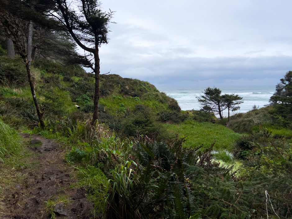
This "secret" part of Cape Meares beach is really beautiful. There is a light waterfall this time of year coming off the rock cliffs into the ocean. There are a few easy streams to cross and then I was easily able to go around the rocky ledge (45.49481, -123.96507) with the tide being where it was at. The tide was coming in and while I was hiking ranged from 2 ft – 3.4 ft.

Once I got to the main stretch of Cape Meares beach it was pretty easy hiking on the wet sand. The wind gusts started to get stronger coming from the west. As I neared the beach access where my mom was waiting to pick me up, really strong gusts blew sand in the air. It was really pretty.

I got to the car just as it started to downpour. I was able to avoid being rained on my whole hike which was quite the unexpected surprise. I definitely found this side of Cape Meares to be prettier than the trail on the south side, but both were unique.

ADD ON: Cape Meares Lighthouse

Mode of access: Hike
Access: Trail
Direction: Round Trip
Distance: 0.55 miles (round trip)
Points of Interest: Lighthouse, expansive ocean views
Date hiked: July 17, 2023
I hiked to this lighthouse with my mom and one of her work friends. It had been years since I'd been there. It was really windy, but the views were stunning. The lighthouse is definitely worth it.

From the parking area the trail is pretty clear cut. It's a somewhat downhill hike to the lighthouse. This is honestly such a beautiful hike. The views along the trail are just as great as the ones at the end. The lighthouse is neat to see up close.

Cape Meares State Scenic Viewpoint Parking Area to Octopus Tree

Mode of access: Hike
Access: Trail
Direction: Round Trip
Distance: 0.57 miles (round trip)
Points of Interest: Octopus Tree, views of Pacific Ocean
Date hiked: March 18, 2024
My mom and I had originally planned to hike the Cape Lookout trail to whale watch, but the whole coastline was fogged in and we decided to change our plans. We headed out to try finding the elusive (to us) Octopus Tree. We'd tried to figure out where it was the previous summer but had been unsuccessful in finding it. Since we had the time we decided to search it out. It ended up being pretty easy to find. The tree is huge and fenced. There's a great view of the ocean beyond the tree. Made for a fun short hike.

Visit the Oregon Coast states that the Octopus Tree is estimated to be around 250 years old. It's a Sitka Spruce and is 105 ft tall.
Octopus Tree to Old Cape Meares Loop Road

Mode of access: Hike
Access: Trail, Road walk
Direction: Round trip
Distance: 1.3 miles (round trip)
Ascent/Descent: +157 ft/ -179 ft
Date hiked: March 20, 2024
I had a few hours before I needed to pick my mom up from work and wanted to do a shorter trail so I decided to go and complete this section as a short, round trip hike. It was rainy and overcast. So I decided it would also be the perfect hike to try out my new rain gear — jacket & pants. There was a pullout on the west side of Old Cape Meares Loop Road where I parked. The trail was just a few hundred feet up the road. It's unmarked but easily visible if you're looking for it.

The trail went through forest and descended a bit following the natural contours of the hillside. There was one footbridge across a small stream and then the trail climbed uphill as it got closer to the area where the Octopus Tree is. There are only a few spots along the trail with views of the ocean. I hiked to the cool lookout near the Octopus Tree and then turned around and hiked back out the way I came. It rained almost the whole time. I didn't come across anyone else on the trail while I was out. This section wasn't as memorable as I thought it might be, but my rain gear held up really well.


Pullout parking coordinates: 45.48240, -123.96748
Trailhead coordinates: 45.48323, -123.96708
Old Cape Meares Loop Road to Oceanside

Mode of access: Vehicle
Access: Road
Direction: North
Distance: 3.3 miles
Points of Interest: Short Beach
Date driven: March 20, 2024
I drove the section of road between Oceanside and the Cape Meares State Scenic Viewpoint and knocked out two road sections in one go. The section between Oceanside and the south side trail, as well as the section between the Cape Meares Beach north trail and the Cape Meares State Scenic Viewpoint parking lot.
The drive is pretty and on a bit of a rougher, older road with potholes and uneven pavement. It passes by Short Beach and the turn-off for the new Cape Meares Loop Road. The Old Cape Meares Loop Road continues to the entrance of the Cape Meares State Scenic Viewpoint and continues to a parking area on a narrower paved road (Lighthouse Road). It's wide enough for two cars to pass at the same time but doesn't have center lines.
ADD ON: Tunnel & Agate Beaches

Mode of access: Hike
Access: Beach
Direction: Round trip
Distance: 1.4 miles (round trip)
Date hiked: July 17, 2023
Tunnel and Agate Beaches are accessible through the tunnel on the north end of Oceanside Beach. The tunnel is rocky but fairly easy to navigate. Tunnel Beach is very rocky and then gives way to sandy beach eventually. I've hiked this section numerous times. Agate Beach is popular for finding agates. I really like coming closer to low tide since there's tons of rock outcroppings that become visible. It's really beautiful. The last time I hiked this I found some agates and proceeded to wack my head on an overhang when I stood up. Definitely not my finest moment. I had a nice bump on my head for a few days after.
Oceanside to Happy Camp

Mode of access: Hike
Access: Trail, Beach, Road walk
Direction: Round trip
Distance: 4.4 miles (round trip)
Points of Interest: Beach, Netarts Bay
Date hiked: May 21, 2021
I've hiked this section of beach numerous times. We had friends of the family who lived between Oceanside and Netarts that we would stay with when my mom came over for work until they recently moved. I'd usually hike down to Happy Camp Beach from their neighborhood and then walk north up to Oceanside before looping back. It's a pretty section of beach. A popular place for locals to walk their dogs. I made the mistake of walking the entire sand section of this barefoot. I was fine in the moment but I dealt with terrible foot cramps after and into the following day.
Happy Camp to Schooner's

Mode of access: Hike
Access: Beach, Road walk
Direction: Round trip
Distance: 2.1 miles (round trip)
Points of Interest: Netarts Bay, Schooner's Restaurant
Tide Alert: "If passing at mid- to high tide you may need to leave the beach at Beach Access 32: Happy Camp and take an alternate route through town." - FarOut. Or wait until below mid-tide to be able to hike beach section.
Date hiked: March 20, 2024
I decided to hike this section as a round trip instead of doing a point-to-point since it was so short and I had some time during the afternoon before I needed to pick my mom up from work. It was overcast, a bit windy, and looked like it might rain. I parked at the Happy Camp Beach parking lot when it was close to low tide. The tide was going out during my hike and ranged from +1.5 ft to +0.7 ft. I had my rain gear on from previously hiking in Cape Meares State Park.
I was able to hike in the wet packed sand until the beach ended and it put me out on Netarts Basin Boat Road. I road walked to the bathrooms near the Netarts Bay Boat Ramp. Then I hiked back the way I came to Happy Camp. On the way back I saw a seagull eating a fish and another one eating a crab it just caught. It started to mist the last 10 minutes of the hike.
Resources
Area Conditions
"Public access near the south jetty, north of Kincheloe Point, via Bayocean Dike Road will be closed all hours and all days until Fall of 2025, or the end of active construction.. Tillamook South Jetty Repairs project will be ongoing from 27 November (2023) to Fall of 2025. At every extended opportunity which will allow for safe public access, Bayocean Dike Road, south of Kincheloe Point, will be open."
Trail Overviews
OregonHikers - Oceanside to Netarts Hike (includes Tunnel & Agate Beaches)
NoahLangPhotography - Hiking to Cape Meares Beach Trail on the Oregon Coast
Information/Maps
Tide
My Wild Adventure is not responsible for your safety, any possible injury, or anything that happens if you choose to follow anything on this website. Maps are not intended to be used for navigational purposes, but to give an overview of the route taken. By going outdoors you are solely responsible to know your strengths and limitations, be aware of current conditions and proceed with the appropriate caution. My Wild Adventure is not responsible for your choices and the outcome. Reference my disclaimer for more information on being responsible outdoors.


