Highway 224 & the Upper Clackamas River - Part 6
- Tina McLain
- Aug 25, 2025
- 9 min read

A break down of all viewpoints, river access points, seasonal waterfalls, and hikes along the Clackamas River from Hole-in-the-Wall Boat Access Site to the Narrows.

Part 6 explores five pull-offs, four waterfalls, one hike, and one boat/river access site. This section is all within national forest.
For more information on activity ideas, resources, safety, and a list of each place by category check out my Highway 224 & Upper Clackamas River - Overview post.
Recreating in Burned Areas
The majority of the Upper Clackamas River was affected by the 2020 fires. Large amounts of the area have reopened as of 2025. There are still a few areas/roads that are closed to public access.
As I’ve noted above, the majority of the Upper Clackamas River was affected by the 2020 fires. Large amounts of the area have reopened as of 2025. There are still a few areas/roads that are closed to public access.
As with any aspect of recreating outdoors, it’s important to make sure what you’re doing is legally open to the public. For up-to-date information on what is open, check out the Mount Hood National Forest website.
Another important aspect to consider when recreating in burned areas is the additional hazards and risks, such as unstable slopes/ground, flash floods, potential for falling trees/limbs, etc.
I really encourage everyone to check out the forest service page, “Safety in Burned Areas,” which discusses how to stay safe in burned areas.
Seasonal Waterfalls Disclaimer
I designate “waterfall” as any amount of water that flows or drops a vertical (or mostly vertical) rock surface. I use the word waterfall rather loosely, and I don’t use any official parameters for what is designated a “waterfall.” Basically if it appears to be falling water, I label it as a “waterfall” for ease of use.
There are a plethora of seasonal waterfalls along the upper Clackamas River. There's no way I could note all of them. So, I'm going to focus on marking those that are 1) most visible from along Highway 224, and 2) the most noticeable/my favorite ones. There are still plenty that I haven’t noted in this post. There are two that I know of that I didn’t add due to it not really being possible to photograph them. So, keep your eyes peeled for waterfalls along the way.
Some are best seen driving a particular direction (east vs. west), so I'll make sure to note which direction has the best visibility when discussing the waterfalls.
Winter/spring is usually the best time to see the waterfalls, particularly after some consistent/heavy rain. There is no guarantee the waterfalls listed will be present at different days/times of year. For the most luck in seeing waterfalls, it’s best to go after there’s been some heavy/prolonged rain along with snow melt.
All seasonal waterfalls are approximate coordinates, it gives the idea of where the waterfall is, but there is room for error on my part.
Pull-offs Disclaimer
I note a majority of the pull-offs along Highway 224, but there are some I’m sure I didn’t cover. It’s as close to being comprehensive as I could get. There is some subjectivity involved as to what constitutes a “pull-off.” So there are some areas others might consider pull-offs that I didn’t note.
There are some pull-offs that have boot paths leading to the river or river views, which I do my best to mention. Most of the photos I took are of the pull-off’s themselves since it is easier to eye that if you go driving yourself. Some places I included pictures of the river, but not in all. I think part of the fun with this list is going to those coordinates and seeing for yourself what it looks like.
Explore the map below to see where each place discussed is located.
Quick Reference

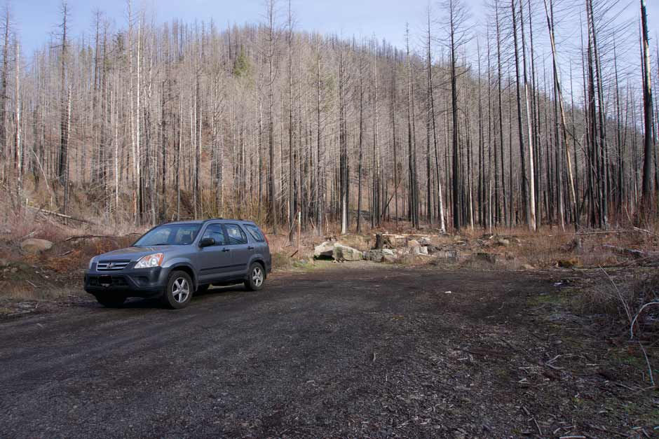
Hole-in-the-Wall Boat Access Site
Coordinates: 45.16482, -122.12207
Use: Boat launch, river access
Activity: White water rafting & kayaking, picnicking
River (access, view, none): Access & view
Facilities: Bathroom & 3 picnic tables
Parking: 3 handicap spots, 14 parking spots, 5 trailer spots
Fee: None
Managed By: PGE
Note: Out of all the river access sites officially managed by PGE this one tends to have the least amount of people from what I've seen.
Easiest driving direction for access: East (towards Ripplebrook), but can be easily accessed driving either direction.
Hole-in-the-Wall is a river access site for white water activities and picnicking. There are 3 picnic tables scattered throughout the day use area and there is a staircase leading down to the river access point.
The shore along the river has places where you could probably find a place to sit. It would just require navigating some drift wood. There’s some pretty rock cliffs on the other side of the river I always enjoy looking at.
Pull-off 45.15929, -122.11797
Coordinates: 45.15929, -122.11797
Use: Parking, Hiking, View of waterfall, Roaring River access
Activity: Target shooting
River (access, view, none): None for the Clackamas River, but is has access & view for Roaring River
Facilities: None
Parking: Room for approximately 4 cars if parked well.
Fee: None
Easiest driving direction for access: I've pulled into this pull-off driving both directions.
Other Posts: For more detailed information check out my post on the Hike to Roaring River From Pull-off 45.15929, -122.11797.
This pull-off is right before the bridge that goes over Roaring River on the north side of the road. It has room for a few cars to park. There’s a foot path that leads north out of the pull-off which leads to a target shooting area. To the east from the target shooting area there are some unmarked boot path type trails that lead to the edge of Roaring River which is gorgeous this time of year. Since this area can be used for target shooting, be very aware of anyone else in the area. I only "hike" when there's no one else here.
There is are two seasonal waterfalls visible from this pull-off on the other side of the Clackamas River towards the south.
Waterfall 45.15833, -122.11948
Coordinates (approximate): 45.15833, -122.11948
Seasonal or Year-Round: Seasonal
Visible From: Highway 224 and pull-off 45.15929, -122.11797
Best Seen Driving: Can be seen driving either direction down Highway 224
I'm pretty sure this waterfall is seasonal. It's rather pretty and cascades down rock cliff face on the south side of the Clackamas River.
The view is somewhat obscured at pull-off 45.15929, -122.11797 by trees, I initially walked down the shoulder of the highway right along the pull-off and it was still a bit obscured. But I discovered that once I walked down the boot path at this pull-off which heads away from the waterfalls, there's actually a point at 45.15962, -122.11776 where the waterfall is most visible!

Waterfall 45.15780, -122.11845
Coordinates (approximate): 45.15780, -122.11845
Seasonal or Year-Round: Seasonal
Visible From: Highway 224 and pull-off 45.15929, -122.11797
Best Seen Driving: East (towards Ripplebrook)
I'm pretty sure this water is seasonal also, it is further east than the other waterfall visible from pull-off 45.15929, -122.11797. This waterfall can't be seen directly from the pull-off, it requires walking about 100 ft east out of the pull-off on the dirt mounds to approximately 45.15927, -122.11750. The waterfall is then visible when looking across the Clackamas River from this location.

Pull-off 45.15698, -122.11417
Coordinates: 45.15698, -122.11417
Use: View of river & rock cliff wall, potential river access during the summer.
Activity: Fishing
River (access, view, none): Access & view
Facilities: None
Parking: Room for 8 cars approximately on gravel shoulder next to highway
Fee: None
Note: The pull-off is right along the sign for the Roaring River Campground (Campground is closed due to fire damage)
Easiest driving direction for access: East (towards Ripplebrook)
This pull-off is on the south side of highway 224 right next to the roaring river campground sign. It’s next to a very beautiful section of river with huge rock cliff walls on the other side of the river. This is a place I have seen people fishing. It’s one of my favorite spots along the river due to the rock cliffs, moss is slowly starting to grow back on them post fire!


Pull-off 45.15041, -122.10482
Coordinates: 45.15041, -122.10482
Use: View of river; parking spot to walk to view of Pup Creek Falls
River (access, view, none): View
Facilities: None
Parking: There's room for multiple cars
Fee: None
Easiest driving direction for access: East (towards Ripplebrook)
This pull-off is right past Sunstrip Campground. It's on the south side of highway 224. It's a good sized pull-off with a mix of gravel and bark chips.
There's another pull of at 45.15038, -122.10405 on the other side of the highway just a little further east. But I wouldn’t recommend using it because there are a lot of large sharp rocks throughout the pull off that aren’t visible until you’re in the pull off. I’d recommend using only the pull off on the south side of the highway.
There's a view of the river from this pull-off, but the river is a little ways away. I didn't see any evident boot path down towards the river, so to reach the rivers edge would require some bushwhacking. It's probably a better place to just stop while sitting in one's car, than a river access point.
This pull-off is also place to park to then walk down the shoulder of highway 224 east, to get a glimpse of Pup Creek Falls. The waterfall is visible when driving past, but there is no "pull-off" at the point the waterfall is visible from the highway. So to be able to "stop" and see it requires walking to the point it's visible.

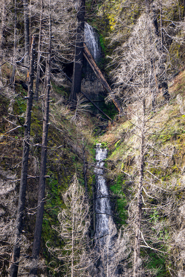
Pup Creek Falls
Coordinates: 45.14678, -122.10563
Seasonal or Year-Round: Year-round
Resources: Waterfalls Northwest
Visible From: Highway 224
Best Seen Driving: West (towards Estacada), but can be seen driving either direction
Other Posts: For more detailed information check out my post on Pup Creek Falls.
Pup Creek Falls is one of the largest waterfalls that runs year round along the Upper Clackamas River. It used to be accessible via the Clackamas River Trail, which is no longer open. But since the fire, it is now visible while driving along Highway 224 (which pre-fire it wasn't visible from the highway).
The only way to see the falls or take a picture is to park in pull-off 45.15041, -122.10482 and then hike east along the shoulder of the highway to 45.14992, -122.10217 where the waterfall becomes visible and I was able to the photo above.
Waterfall 45.14981, -122.09756
Coordinates (approximate): 45.14981, -122.09756
Seasonal or Year-Round: Seasonal
Visible From: Highway 224
Best Seen Driving: West (towards Estacada)
This waterfall is another one of my favorites and easy to miss. It's on the northeast side of highway 224 and within a narrow canyon. It's easiest to see driving west due to how it's angled. The waterfall has two tiers and is really only possible to see driving by. There is no easy pull-off or place to stop to view it. Plus the whole rock cliff along this section of road is a rock fall zone.

Pull off 45.14577, -122.09269
Coordinates: 45.14577, -122.09269
Use: Sitting in car or emergency pull-off
River (access, view, none): None
Parking: Room for approximately 4 cars
Fee: n/a
Note: More an emergency pull-off or a place to just stop in ones car.
Easiest driving direction for access: West (towards Estacada)
This pull off is on the east side of highway 224 just after coming out of a sharp corner when driving west towards Estacada.
I would call this more of an emergency pull-off, not really a view of much. It has no river access and it’s right out of a sharp corner. It’s on the hill side of the road, not the river side. there’s room for about 4 cars. I think this pull-off was created when they were doing construction along the road post-fire.

Pull off 45.14384, -122.09059
Coordinates: 45.14384, -122.09059
Use: Sitting in car and view of river
River (access, view, none): View
Facilities: None
Parking: There's room for multiple cars, maybe 6
Fee: None
Easiest driving direction for access: East (towards Ripplebrook)
This pull-off is on the south side of the highway and located on a sharp corner. It has a view down to the river which is approximately a 60 foot drop below. This pull-off is more of a viewpoint or sit in your car kind of place. The slope is too steep to access the river.

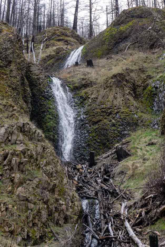
Coordinates (pull-off): 45.14013, -122.08431
Coordinates (the narrows): 45.14050, -122.08519
Access: Unmarked & unnamed trail
Distance: 0.36 miles (round trip)
Use: View of river, river access
Activity: Hiking, Swimming, Picnicking
Facilities: None
Parking: There is a wide shoulder that is used for parking. There is room for approximately 8 cars.
Fee: None
Note: The trailhead isn't marked.
Easiest driving direction for access: East (towards Ripplebrook)
Other Posts: For more detailed information check out my post on the Narrows.
The Narrows is a section of the Clackamas River that is lined with cool rock outcroppings. It's a swimming hole during the summer due to the cliffs and some deeper sections of water. It's also just very pretty and cool to explore.
The Narrows are accessed from pull off 45.14013, -122.08431 and the trailhead starts at 45.13992, -122.08442.

My Wild Adventure is not responsible for your safety, any possible injury, or anything that happens if you choose to follow anything on this website. Maps are not intended to be used for navigational purposes, but to give an overview of the route taken. By going outdoors you are solely responsible to know your strengths and limitations, be aware of current conditions and proceed with the appropriate caution. My Wild Adventure is not responsible for your choices and the outcome. Reference my disclaimer for more information on being responsible outdoors.


