Highway 224 & the Upper Clackamas River - Part 4
- Tina McLain
- Aug 11, 2025
- 8 min read

A break down of all viewpoints, river access points, seasonal waterfalls, and hikes along the Clackamas River from Clackamas Highway Quarry to Angel Falls.

Part 4 explores five pull-offs, five waterfalls, and one day use site. This whole section is within national forest.
For more information on activity ideas, resources, safety, and a list of each place by category check out my Highway 224 & Upper Clackamas River - Overview post.
Recreating in Burned Areas
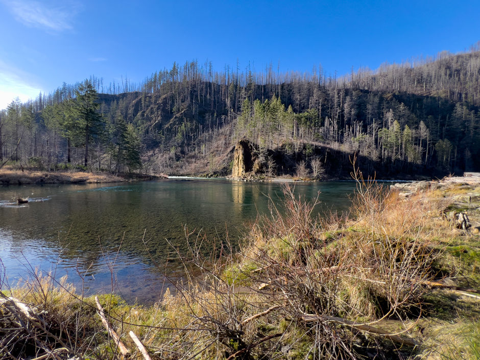
The majority of the Upper Clackamas River was affected by the 2020 fires. Large amounts of the area have reopened as of 2025. There are still a few areas/roads that are closed to public access.
As I’ve noted above, the majority of the Upper Clackamas River was affected by the 2020 fires. Large amounts of the area have reopened as of 2025. There are still a few areas/roads that are closed to public access.
As with any aspect of recreating outdoors, it’s important to make sure what you’re doing is legally open to the public. For up-to-date information on what is open, check out the Mount Hood National Forest website.
Another important aspect to consider when recreating in burned areas is the additional hazards and risks, such as unstable slopes/ground, flash floods, potential for falling trees/limbs, etc.
I really encourage everyone to check out the forest service page, “Safety in Burned Areas,” which discusses how to stay safe in burned areas.
Seasonal Waterfalls Disclaimer
I designate “waterfall” as any amount of water that flows or drops a vertical (or mostly vertical) rock surface. I use the word waterfall rather loosely, and I don’t use any official parameters for what is designated a “waterfall.” Basically if it appears to be falling water, I label it as a “waterfall” for ease of use.
There are a plethora of seasonal waterfalls along the upper Clackamas River. There's no way I could note all of them. So, I'm going to focus on marking those that are 1) most visible from along Highway 224, and 2) the most noticeable/my favorite ones. There are still plenty that I haven’t noted in this post. There are two that I know of that I didn’t add due to it not really being possible to photograph them. So, keep your eyes peeled for waterfalls along the way.
Some are best seen driving a particular direction (east vs. west), so I'll make sure to note which direction has the best visibility when discussing the waterfalls.
Winter/spring is usually the best time to see the waterfalls, particularly after some consistent/heavy rain. There is no guarantee the waterfalls listed will be present at different days/times of year. For the most luck in seeing waterfalls, it’s best to go after there’s been some heavy/prolonged rain along with snow melt.
All seasonal waterfalls are approximate coordinates, it gives the idea of where the waterfall is, but there is room for error on my part.
Pull-offs Disclaimer
I note a majority of the pull-offs along Highway 224, but there are some I’m sure I didn’t cover. It’s as close to being comprehensive as I could get. There is some subjectivity involved as to what constitutes a “pull-off.” So there are some areas others might consider pull-offs that I didn’t note.
There are some pull-offs that have boot paths leading to the river or river views, which I do my best to mention. Most of the photos I took are of the pull-off’s themselves since it is easier to eye that if you go driving yourself. Some places I included pictures of the river, but not in all. I think part of the fun with this list is going to those coordinates and seeing for yourself what it looks like.
Explore the map below to see where each place discussed is located.
The map notes all the different points I mention in this post. Each color corresponds to the "Part" it is included in.
Quick Reference

Clackamas Highway Quarry
Coordinates: 45.19630, -122.18027
River (access, view, none): None
Parking: There is no are for parking near the entrance of the quarry and there are no parking signs along the guardrail near it. Best place for parking would we one of the pull-offs before or after.
Note: I’m noting the quarry since the entrance is visible from the road, but it isn’t really a place to explore post-fire.
This isn't really a place to stop anymore. Before the wildfires it was a place people would target shoot, but it's now posted that "Target Shooting is Prohibited." For the legalities of target shooting on national forest land reference the Forest Service website.

Pull-off 45.19473, -122.17818
Coordinates: 45.19473, -122.17818
River (access, view, none): None
Parking: This loop, pull-off isn't so much a place to park as it is a place potentially to turn around. On the north end, there might be enough room for a few cars to park, but you wouldn't want to park in the loop blocking it for others, or risk getting boxed in by other cars if going during the summer months.
Fee: n/a
Note: This is more a turn around point, doesn't really provide access to anything
Easiest driving direction for access: West (towards Estacada)
This "pull-off" along the east side of Highway 224 is more a short gravel loop that could be used for turning around. The gravel is in good condition. As I mentioned above, it's not the best place to park.
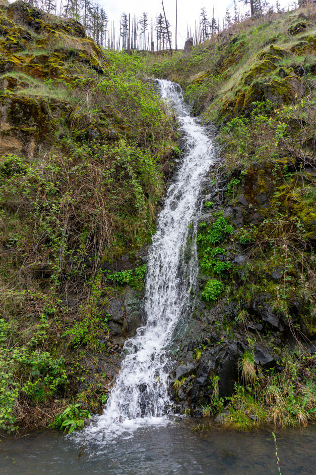
Waterfall 45.18947, -122.16837
Coordinates (approximate): 45.18947, -122.16837
Seasonal or Year-Round: Year-Round (but flow significantly decreases)
Visible From: Highway 224
Best Seen Driving: Can be seen driving both directions. But to stop and see it, it's best to do that driving West (towards Estacada)
This waterfall drops down a rock face and almost has more of a creek like quality to it. It is very close to "waterfall 45.18900, -122.16808" which is just a 100 ft further east down highway 224. So when driving East (towards Ripplebrook) this is the first of the two waterfalls you'll come across.

Waterfall 45.18900, -122.16808
Coordinates (approximate): 45.18900, -122.16808
Seasonal or Year-Round: Year-Round (but flow significantly decreases)
Visible From: Highway 224
Best Seen Driving: Can be seen driving both directions
This waterfall is one of the most prominent ones along the cliffs that line the west side of highway 224 in this section. It falls right next to the road. When it's cold enough to be icy out, ice builds up on the chain link fence that covers the rock cliff face in this section. It's really beautiful.

Waterfall 45.18661, -122.16739
Coordinates (approximate): 45.18661, -122.16739
Seasonal or Year-Round: Seasonal
Visible From: Highway 224 and pull-off 45.18529, -122.16985
Best Seen Driving: Can be seen driving both directions, but you can see if for longer when driving west (towards Estacada)
This waterfall starts further up the rock cliffs, it has a beautiful drop and then cascades down rocks closer to the road. It's visible when driving by and from pull-off 45.18529, -122.16985.

Pull-off 45.18529, -122.16985
Coordinates: 45.18529, -122.16985
Use: Boat launch point for whitewater kayaking/rafting; view of seasonal waterfall
Activity: Kayaking, rafting
River (access, view, none): Access & view
Facilities: None
Parking: At least 8 cars, definitely room for a good amount
Fee: None
Easiest driving direction for access: East (towards Ripplebrook), but could be safely accessed driving in either direction.
This is an unassuming pull-off that is a popular put-in site for white water kayaking/rafting. It's not uncommon to see other vehicles here. An unnamed waterfall (45.18661, -122.16739) is visible from this pull off when looking NE.
There's an established boot path that leads down to the Clackamas River. There is a small, sandy beach section along the river that is a great put-in spot.

Pull-off 45.18272, -122.17324
Coordinates: 45.18272, -122.17324
Use: View of river and waterfall on other side of river
Activity: Picnicking
River (access, view, none): Access & view
Facilities: None
Parking: Room for a few cars
Fee: None
Note: This pullout is another 4x4 road pull-off, except one section of the 4x4 road is steep, so unless you have the right vehicle the 4x4 road should be used as a one-way. There's room at the end of each side to park on the shoulder of the road.
Easiest driving direction for access: East (towards Ripplebrook), but could safely be accessed driving in either direction.
This pull off is right before Big Eddy Day Use Site. It's around the U shaped corner. This is another pullout with a 4x4 road that quickly climbs to the top of a little hill, right along the highway. There's room to park at the pull off along the the highway and not have to. use the 4x4 road.
At the top of the hill there is a view of a seasonal waterfall on the other side of the river. Behind the hill there a a bit of a shelf where it looks like one could picnic. The river is rather pretty and can be viewed all along the pullout. A particularly pretty section is viewable from 45.18262, -122.17336.


Waterfall 45.18102, -122.17571
Coordinates (approximate): 45.18102, -122.17571
Seasonal or Year-Round: Seasonal
Visible From: Highway 224 and the hill at pull-off 45.18272, -122.17324
Best Seen Driving: Both directions
This seasonal waterfall is on the west side of the river. It has two tiers and the rock has been smoothed from the water flow. It's framed by mossy rock and is rather pretty.
The waterfall can be seen when driving down highway 224. The top tier is visible from the top of the pull-off hill at 45.18288, -122.17372. The lower tier is partially viewable further north along the footpath at 45.18328, -122.17367.
Big Eddy Day Use/Picnic Site
Coordinates: 45.18227, -122.16852
Use: River access
Activity: Fishing, Picnicking, Swimming
River (access, view, none): Access & view
Facilities: Bathroom
Parking: There is a huge, and long very wide pull-off. Room for well over 30 vehicles to park.
Fee: None
Managed By: Forest Service
Resources: Forest Service
Note: There is a lot of driftwood along the shore.
Easiest driving direction for access: Can be accessed driving both directions
Big Eddy Day Use Site is right by a huge pull-off that wraps around a corner. It has tons of spaces for many many cars. There's a restroom and a wide path that goes down hill with a descent of about 20 ft. It's a very short walk of 0.06 miles to the edge of the river. Along the shore to the west there's a lot of huge boulders and to the east the shore is less rocky. Both shores are covered in varieties of driftwood post-fire, so it requires some scrambling over wood to go further down the "beach" in either direction. Big Eddy is located at a point along the Clackamas River where it bends and it creates some unique water currents that can end up looking like a whirlpool.

Pull-off 45.17558, -122.16314
Coordinates: 45.17558, -122.16314
Use: View of waterfall on east side of road
River (access, view, none): None
Facilities: None
Parking: This pull-off is just a wide shoulder on the west side of the road. There isn't room for many cars, maybe 4.
Fee: None
Note: Waterfall is visible from pull-off
Easiest driving direction for access: East (towards Ripplebrook)
This pull-off is on the west side of the road at mile point 38 and is just a wide shoulder section. It's not good for river access or even viewing the river, but it gives a great view of a 3 tiered waterfall on the east side of the road.

Angel Falls
Coordinates 1st Tier (approximate): 45.17699, -122.16015
Coordinates 2nd Tier (approximate): 45.17676, -122.16063
Coordinates 3rd Tier (Angel Falls): 45.17625, -122.16136
Seasonal or Year-Round: Seasonal
Resources: Waterfalls Northwest
Visible From: Highway 224 and pull-off 45.17558, -122.16314
Best Seen Driving: East (towards Ripplebrook)
This waterfall actually has a name, "Angel Falls." It looks like there's 3 tiers to the falls (at least to me) and the 3rd tier is the one named Angel Falls according to Waterfalls Northwest. They note the falls has a 65 ft drop and is considered seasonal.
I think this is a very beautiful waterfall. the last tier looks like a horseshoe style drop. I think it's well worth the quick stop at the pull-off to see this waterfall.
My Wild Adventure is not responsible for your safety, any possible injury, or anything that happens if you choose to follow anything on this website. Maps are not intended to be used for navigational purposes, but to give an overview of the route taken. By going outdoors you are solely responsible to know your strengths and limitations, be aware of current conditions and proceed with the appropriate caution. My Wild Adventure is not responsible for your choices and the outcome. Reference my disclaimer for more information on being responsible outdoors.


