Clear Lake
- Tina McLain
- Apr 23, 2020
- 4 min read

Updated: Apr 19, 2024
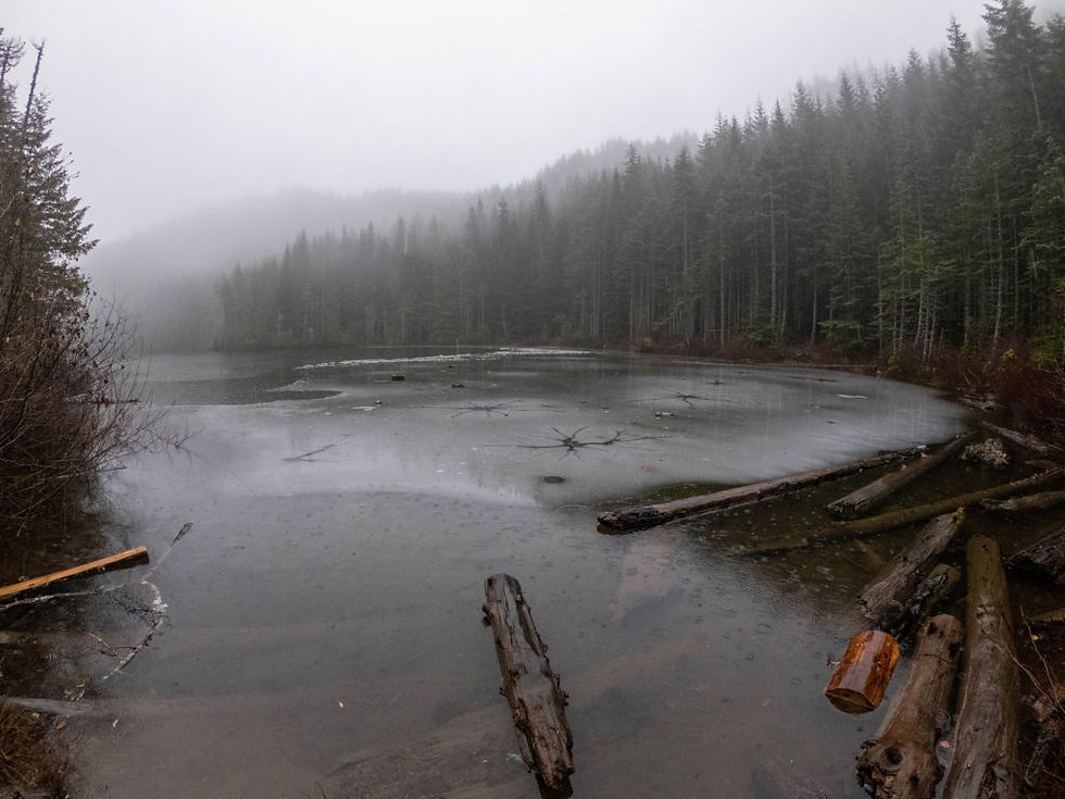
A backwoods lake situated below Goat Mountain in Mount Hood National Forest.
Lake Name: Clear Lake Lake Coordinates: 45.1336, -122.2895 Lake Elevation: 3850′ Access: Decommissioned forest service road & bushwhack Route: Decommissioned forest service road to lake from a quarry Bushwhack Rating: BW 2/3 Distance: 1.4 miles (round trip) Trail Type: In and out; or lollipop when bushwhacking Note: There is no “official” trail to the lake. I plotted a course on a decommissioned forest service road that took us easily to the lake. We bushwhacked along the edge of the lake then cut back to the road. You don’t have to bushwhack to get to the lake. Date accessed: 11-29-19
There is no “hiking trail” to Clear Lake and it was very difficult to find anything about it on the internet. The only place I was able to find something was on a forum site from 2012. It took me a few tries to figure out where the lake even was because there is a maze of unmarked roads surrounding the area. The forest service map helped a lot, but it still took me two tries to figure out where I might even be able to access the lake. The roads around the area of the lake are very confusing.
I went into Google Maps in satellite mode and figured out where I’d driven and found what appeared to be an old road that led to the lake from the gravel pit I’d driven to and turned around in.
So on a rainy Saturday afternoon my dad and I went to see if my idea on how to access the lake would work. We drove to the gravel pit and parked. There is a big berm blocking the “old service road” we discovered. To the right of it, there was a narrow road that people had made to go around it. We hiked down the road which was pretty flat with maybe a slight slant uphill, but nothing major. The road was in pretty good condition and it looked like there had recently been vehicles down it.
As we neared the lake, we reached a hill that quickly went down to the level of the lake. We would sort of see parts of the lake through the trees to our left. We walked down the road which kind of slanted in a “V” inwards from both sides. We continued down until it leveled out and the road took us around to a point where it met the lake. There were tons of bullet shells all over the ground near the lake. That’s where the lake was frozen over a bit.
We walked back up the road we came down and went down a road that went along the lake a little and dead ended. It was raining pretty hard and was pretty foggy out. We wanted to see if we could find a trail to the top of Goat Mountain on the other side of the lake. So we bushwhacked along the side of the lake. We heard a car go by and a minute or two later gun shots started.
Some people had come down to the end of the lake where we’d just been and were target shooting. So we decided to cut up to the road and not try to figure out how to get to goat mountain since it was rainy and cold. The rhododendron bushes were really thick and hard to get through. I ended up on my butt twice because the rhodies fought back. It didn’t really hurt, it just made me laugh. My dad would turn around and not be able to see me until he looked down and found me laughing.
We got back to the road and we were totally soaked. We walked back down the road to our truck.

Resources
For more information about bushwhacking reference my disclaimer page.
Update 2022: I was able to find more information about his lake from the ODFW about fish stocking and added the link above. This lake is stocked with cutthroat trout every 2 years.
How to get there (from Estacada, OR)
From the Estacada Bridge continue down OR-211 for 4.7 miles. Turn left on to S Hillockburn Rd. Continue on S Hillockburn Rd (turns into NF-45 at National Forest border) for 9.2 miles. The road will come to a four-way split. Continue on the road slightly to right, NF 4520. Continue on NF-4520 for 1.7 miles until the road comes to a T. Turn right on NF-4510 and continue straight down road for 0.4 miles. The road will come to a slight V. Stay on the road that continues straight for a couple hundred feet and you’ll arrive at the quarry.
Location
Lake Coordinates: 45.1336, -122.2895
Clackamas River Ranger District map location: T5S R4E S14
Maps

Curtesy of © Google Maps/Google Earth
TH – There is no official trailhead, but this is where I started Green X – Quarry Green Line – Shows where road continues on to quarry White Line – Shows route taken following old forest service road as the “trail” to the lake Yellow line – The part bushwhacked along the lake that then met up with the road *You can just follow the old forest service road in and out. You don’t have to bushwhack to get to the lake.
The Google Map pin above shows the road right before the gravel pit for reference. (In Google Maps the coordinates are: 45.132765, -122.283386)
What I personally did was, after trying to just go off the forest service map and not being able to tell which road I was on was I pinned this location and got directions from Google Maps and followed those there. NOTE: This was when I was still in the early days of figuring out navigation tools. I would now use Gaia GPS or another navigation app or device to navigate.
My Wild Adventure is not responsible for your safety, any possible injury, or anything that happens if you choose to follow anything on this website. Maps are not intended to be used for navigational purposes, but to give an overview of the route taken. By going outdoors you are solely responsible to know your strengths and limitations, be aware of current conditions and proceed with the appropriate caution. My Wild Adventure is not responsible for your choices and the outcome. Reference my disclaimer for more information on being responsible outdoors.


