Frying Pan Lake
- Tina McLain
- Jun 15, 2020
- 3 min read
Updated: Apr 28, 2024
A hidden, quiet lake with a glimpse of Mt Hood in Mount Hood National Forest.

Lake Name: Frying Pan Lake Lake Coordinates: 45.1889, -121.7930 Lake Elevation: 3989′ Access: Drive up (to access the lakes edge requires a very short bushwhack of sorts, definitely a BW 1 not hard at all) Note: There is no visible point of access or well worn trail to the lake. Date Accessed: 5-29-20
Frying Pan Lake is one of those lakes I saw on a map and decided I’d try going to it. I had no idea if I’d be able to, or what the roads were like. Last summer (end of July) was the first time I drove by. I didn’t actually go to the lake, but I did drive down the road near it. It was covered in small frogs. I couldn’t get out and walk without stepping on them. It was so cool.
I decided I was going to stop by and actually take a picture of the lake this time round. I thought it was just a small lake from what I’d glimpsed through the trees before and man, was I wrong.
There seems to be a permanently muddy section of road. Right before there are two places on either side of the road that a car could back into. I parked in one of them. I walked up the road a little ways and found a “no vehicles” sign on some trees on the left side of the road. I saw part of the lake in the distance through the forest.


I walked through the forest for about 100 feet and came out in a large, soft ground area, like sort of muddy, but not. I didn’t sink, but it was sort of spongy. I saw the lake and walked towards and parallel to it. Turns out it was a lot bigger than I thought it was. It is actually a very good sized lake.
I was shocked to see the top of Mt. Hood in the distance on the opposite side of the lake. I was the only person there (my favorite thing). I, of course, had to take pictures. The shape of the lake was very unique. I didn’t try to walk all the way around it. My feet were hurting from hiking the Timothy Lake loop earlier in the day so I was just in sandals. I was very easily able to find my way back to the road and to my car.
There were 2 small patches of snow I saw on the side of the road near the lake, but the road and lake area was snow free.
Resources
I couldn’t find anything online about this lake once I looked it up afterwards. It’s on the Zigzag Ranger District map and that’s really the only resource I know of.
How to get there (from Estacada, OR)
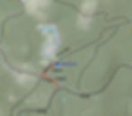
Take Hwy 224 out of Estacada for 24 miles. Turn left on to FS 57 and continue for 7.4 miles until the road Y’s. Stay to the left (turns into FS 58) and continue on 58 for 13 miles. Turn left on to FS 5880 and proceed on road for 1100 feet. The first road to the right is Abbott Rd. Turn right and continue down road for 1100 feet. There are two wider areas on the side of the road that a vehicle could park in. They are before the obvious muddy section of the road.

Location
Lake Coordinates: 45.1889, -121.7930
Zigzag Ranger District map location: T4S R8E S26
Map
My Wild Adventure is not responsible for your safety, any possible injury, or anything that happens if you choose to follow anything on this website. Maps are not intended to be used for navigational purposes, but to give an overview of the route taken. By going outdoors you are solely responsible to know your strengths and limitations, be aware of current conditions and proceed with the appropriate caution. My Wild Adventure is not responsible for your choices and the outcome. Reference my disclaimer for more information on being responsible outdoors.
