Flag Point Lookout & Flag Point
- Tina McLain
- Jan 4, 2021
- 3 min read

Updated: Jun 17, 2024
A lookout tower with great views of Mt Hood in Barlow Ranger District in Mt Hood National Forest.

Peak Name: Flag Point
Peak Coordinates: 45.317935, -121.466625 Peak Elevation: 5651′ Access: Trail/Road Distance: 1.11 miles (round trip) Elevation Range: 5139′ to 5650′ Ascend/Descend: +78 ft / -40 ft
Route Type: In and out Route: FS 2730-200 and an unmarked trail
Outing Type: Day hike
Permits/Fees: None
Note: The lookout tower is closed most of the year, but can still be hiked up to.
Location: Along the north edge of Badge Creek Wilderness in Mt Hood National Forest, Oregon, U.S.A.
Administration: Mount Hood National Forest
Ranger District: Barlow Ranger District
Date Accessed: October 17, 2020

I’d seen Flag Point Lookout on my map many times and we decided to see if we could get there. We drove up the road, leading to the lookout. There was a gate blocking the road near the top so we parked by it and hiked the rest of the way up to the tower. There was room for 2 cars to park off the road near the gate.

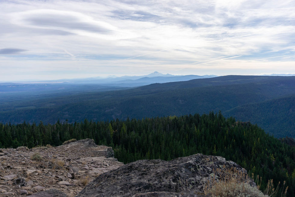
It was a road walk clear up to the tower. There was a cabin, an outhouse, some random buildings, and the lookout tower. We were able to climb up to “almost” the top of the tower. The top level was locked off so we were able to go to the level right below it. We could see many mountains from the tower: Mt Adams, Mt Hood, Mt Jefferson, Three Sisters, and on a clear day Mt Rainier. It was such a cool view!

I climbed back down the tower. There was a sign for a trail that went down to the bottom of Badger Creek Wilderness. Between that trail and the outhouse there was a lightly worn, unmarked “trail.” I was curious so I followed it.

It ended up leading to the edge of Flag Point (the peak the lookout tower is on.) The view was spectacular. I could see the southern Oregon (desert), Three Sisters, Mt Jefferson, Mt Hood, and the whole expanse of the Badger Creek Wilderness. Along the edge of Flag Point, the hillside quickly descended and in some areas cliffs dropped off right on down to the Badger Creek Wilderness valley floor. I could have sat there for hours and been rather happy.

We hiked back down the unmarked trail to the road and then back to our car. We only saw 2 other people from a distance. Most days, especially weekdays this time of year, I’d expect there would be no one around.
Resources
How to get there (from Sandy, OR)
How Hwy 26 out of Sandy for 31 miles. Take the exit for OR-35 N. Continue on Hwy 35 for 12.5 miles. Turn right on NF 44 and proceed for 8.6 miles. Turn right on NF 4420 (turns into 2730) continue for 5.2 miles. Turn right on NF 2730-200 and proceed for 3 miles. There is a gate that was closed when I went. There is room for 2 cars to park on the left side of the road.
Location
Viewpoint Coordinates: 45.317935, -121.466625
Barlow Ranger District map location: T3S R11E S7
Map
My Wild Adventure is not responsible for your safety, any possible injury, or anything that happens if you choose to follow anything on this website. Maps are not intended to be used for navigational purposes, but to give an overview of the route taken. By going outdoors you are solely responsible to know your strengths and limitations, be aware of current conditions and proceed with the appropriate caution. My Wild Adventure is not responsible for your choices and the outcome. Reference my disclaimer for more information on being responsible outdoors.


