Averill Lake & Red Lake
- Tina McLain
- Dec 15, 2025
- 7 min read

A hike to two lakes on the western side of Olallie Lake Scenic Area in Mount Hood National Forest.

Access: Road walk & trail
Distance: 4.61 miles (round trip)
Elevation Range: 3624' to 4698'
Ascent/Descent: +1044 ft/-1047 ft
Route Type: In & out
Route: Road walked up NF-076 to Red Lake Trail #719 and took trail to lakes (within heavily burned area — trail is not always easily visible and requires navigation)
Outing Type: Day hike
Permits/Fees: None
Notes: This hike was within an extensively burned area.
Location: Near Potato Butte in Olallie Lake Scenic Area in Mount Hood National Forest, Oregon, U.S.A.
Administration: Mount Hood National Forest
Ranger District: Clackamas River Ranger District
Area: Olallie Lake Scenic Area
Date Accessed: September 12, 2025

I was pretty excited to get to explore the west side of Olallie Lake Scenic Area and maybe try some fishing. I'd read some more recent trip reports about the Red Lake Trail #719 on AllTrails which helped me decide how to approach this hike. I took NF-380 south past the Red Lake Trailhead. I parked near where the power lines go across the road. There was a shoulder area wide enough for me to pull off the road and park. I then road walked up to NF-076 which is the usually gated road that goes along the power lines.

There was construction happening with numerous dump trucks driving the road. Since I was road walking up, I kept stepping off the road when a dump truck would come by. The road was rather steep.

I made it up the road and discovered the "trail" initially is another road. So I hiked up it for about 300 ft before the trail became apparent on the east side of the road. There was a flagging at the start of the trail.

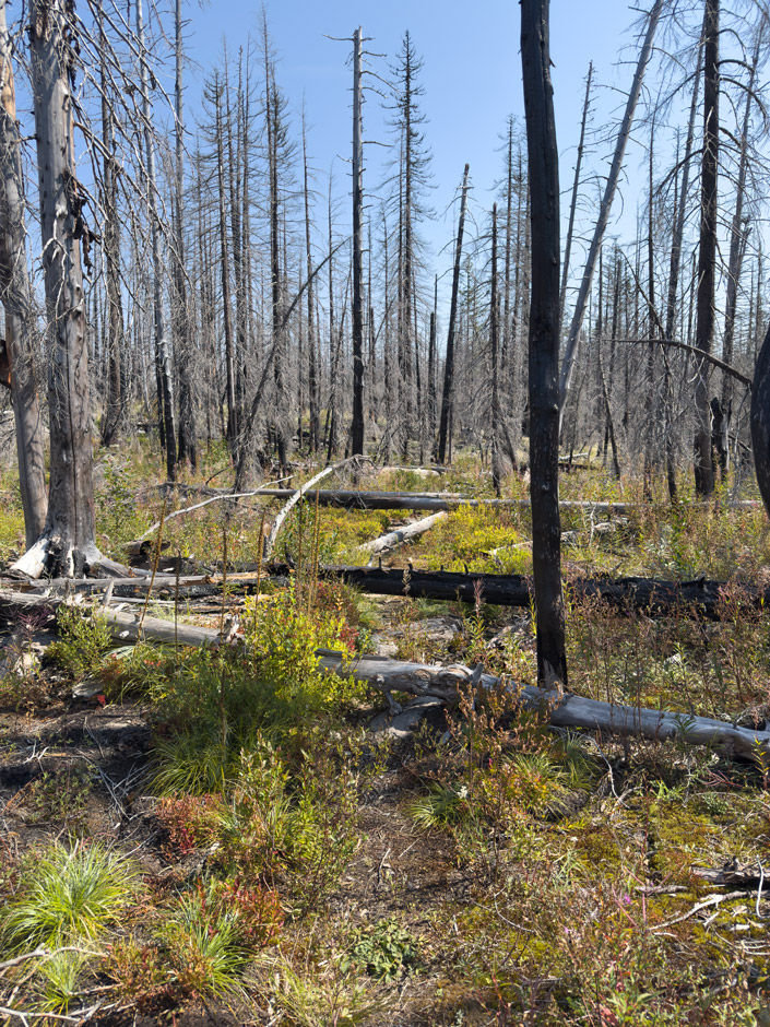
It passed under the power lines while traveling along the hillside. Then the trail came up to the extensively burnt forest that covers the surrounding area from the fires in 2020. I took a break before starting my way into the forest. The trail was a bit difficult to eye at the start and there was a bit of flagging someone had put up to try and help with the obscure parts of the trail. There was also the occasional "Timber Trail" marker on trees. I definitely had to navigate and check my maps regularly on this trail to make sure I stayed on it. Sometimes it would be obvious, and other times it would seemingly disappear.
There appeared to be trees cut (a while ago, not fresh) which made me wonder if the flagging originated from a trail maintenance crew. Once I was back home I did look up if the Trail Advocated had done any trail work, which they had, but who knows where the flagging came from.

I wouldn't rely solely on the flagging along the trail, it definitely required some navigation skills and maps. I ended up hearing a lot of birds and the occasional chipmunk on my hike. I even saw a pileated wood pecker 10 ft away from me at one point. The trail was a combination of rock, exposed roots, and loose dirt. The trail climbed uphill the entire way and there weren't any switchbacks. The grade wasn't terrible, but it was decently steep.

The most obscure section of trail was around Cub Creek which was completely dry. The trail seemingly disappeared completely on and off in this section. There was flagging and I extensively used my GPS/maps in this section. I looked back periodically so it was familiar when I hiked back out later.

There were no other boot prints on the trail going in, only animal prints, some various animal scat, and what appeared to be a set of mountain bike tracks.


The last uphill climb before Red Lake had a bit of trail erosion in a few sections, but they were easily passable. Once I neared where the trail went along Red Lake, the undergrowth and brush became more pronounced. I decided to head to Averill Lake first before exploring Red Lake. I continued up the trail.
The section of trail along Red Lake had the most blow downs over the trail from the whole hike. There were two sections that required a bit of climbing/balance-beam-walking to get over.

There was one section of the trail that was overgrown between the two lakes, with tall brush (like 6 ft tall) I got to push my way through at 44.81460, -121.85068. It wasn't too bad to get through and only lasted about 20 ft.

Lake Name: Averill Lake
Lake Coordinates: 44.8156, -121.8449
Lake Elevation: 4650'

I made it to Averill Lake and came across the first green trees I saw on my hike. There was a small unburnt patch of trees near the lake, and even a campsite. I ended up having my lunch next to the lake. There were some large rock slabs along the shore that I just laid on. I could see Potato Butte and Olallie Butte in the distance. I decided I'd try fishing at Red Lake instead of Averill Lake due to how shallow Averill was and there being no sign of fish.

Lake Name: Red Lake
Lake Coordinates: 44.8129, -121.8522
Lake Elevation: 4550'
Note: There is a lake near Red Lake, named David Lake, but I didn't feel up for the off trail trek that would require.
Once I made it back to Red Lake I found a path of least resistance and made my way to the lake's edge. The entire area was completely burnt. No green trees in sight. There was a destroyed campsite that I sat down at and got my fishing pole all set up. It wasn't really camp-able anymore with all the burnt trees and downed trees. The shore was rocky with squishy mud. I made my way out on to a rock and attempted to fish. I was worn out, it was mid-day (not prime fishing time), and I was done after only a few casts. Between smacking myself in the face with the bubble because I forgot to disengage the lock on my reel then on my third cast snagging my hook on a log underwater, I was done. I was ready to head back. I was struggling a bit with the heat since due to the entire forest being burnt it was all exposed to the sun and there was pretty much no shade.

It was pretty much all downhill back down the trail and road. I wasn't feeling too good and had to take it slow. I made it back to the road sections and there were numerous dump trucks that went by. The drivers waved and were overall friendly. The road was steep, which completely killed my knees. My legs were shaking like Bambi (such is life with chronic illness lol). I finally made it back to the car and discovered two other vehicles parked near mine. I hadn't seen anyone else on the trail. I did think at one point I heard other people talking while fishing, but it was brief enough I wasn't sure. I was able to occasionally hear the backing up beeping from the dump trucks in the distance along my hike. If there wasn't construction the area, would be rather quiet.

I actually think the section of Red Lake Trail #719 that connects NF-380 to NF-076 might have been passable. The trail was evident along the powerline road (NF-076), and when I drove back by the trailhead, I was able to make out some flagging so potentially some trail work has been done. I'll have to check that portion out when I eventually come back to explore David Lake (which is off trail near Red Lake).

Water sources: There were no water sources this time of year along the trail except for the lakes. All the creeks were completely dry.
Resources
TrailAdvocates (they note trail work on the west end has been done, which I was wondering about when I was out hiking with how decent the trail was for how severe the burn was, there had been downed trees cut and flagging)
AllTrails (referenced Hedgehog's trip report from June 8, 2025)
Coordinates
Where I parked under power lines along NF-380: 44.81701, -121.87149
Start of NF-076: 44.81504, -121.87010
Intersection of NF-076 and unnamed gravel rd: 44.82135, -121.86656
Start of Red Lake Trail #719 (under power lines): 44.82050, -121.86656
Red Lake: 44.8129, -121.8522
Red Lake shore: 44.81327, -121.85241
Tall bush section of trail: 44.81460, -121.85068
First clump of green trees I saw: 44.81583, -121.84791
Campsite near Averill Lake: 44.81588, -121.84641
Averill Lake: 44.8156, -121.8449
Averill Lake shore (where I ate lunch): 44.81553, -121.84603
Forest Service Map Location
Averill Lake: T9S R8E S04
Red Lake: T9S R8E S08
How to get there (from Estacada, OR)
Take Hwy 224 E (turns into FS 46) out of Estacada for 51.8 miles. Turn left on NF-380 and proceed for 1.2 miles. Park along shoulder of road near power lines. Then road walk up to NF-076/power line road.
Map
My Wild Adventure is not responsible for your safety, any possible injury, or anything that happens if you choose to follow anything on this website. Maps are not intended to be used for navigational purposes, but to give an overview of the route taken. By going outdoors you are solely responsible to know your strengths and limitations, be aware of current conditions and proceed with the appropriate caution. My Wild Adventure is not responsible for your choices and the outcome. Reference my disclaimer for more information on being responsible outdoors.

